
环游之路各段详情
下滑
简介
沿瑞士环游之路自驾需要做好充分准备。为此,瑞士国家旅游局汇集了详细情况,包括各路段的距离、上下坡总长度等信息。如此一来,就没有什么能够阻挡体验难忘的瑞士自驾之旅了。
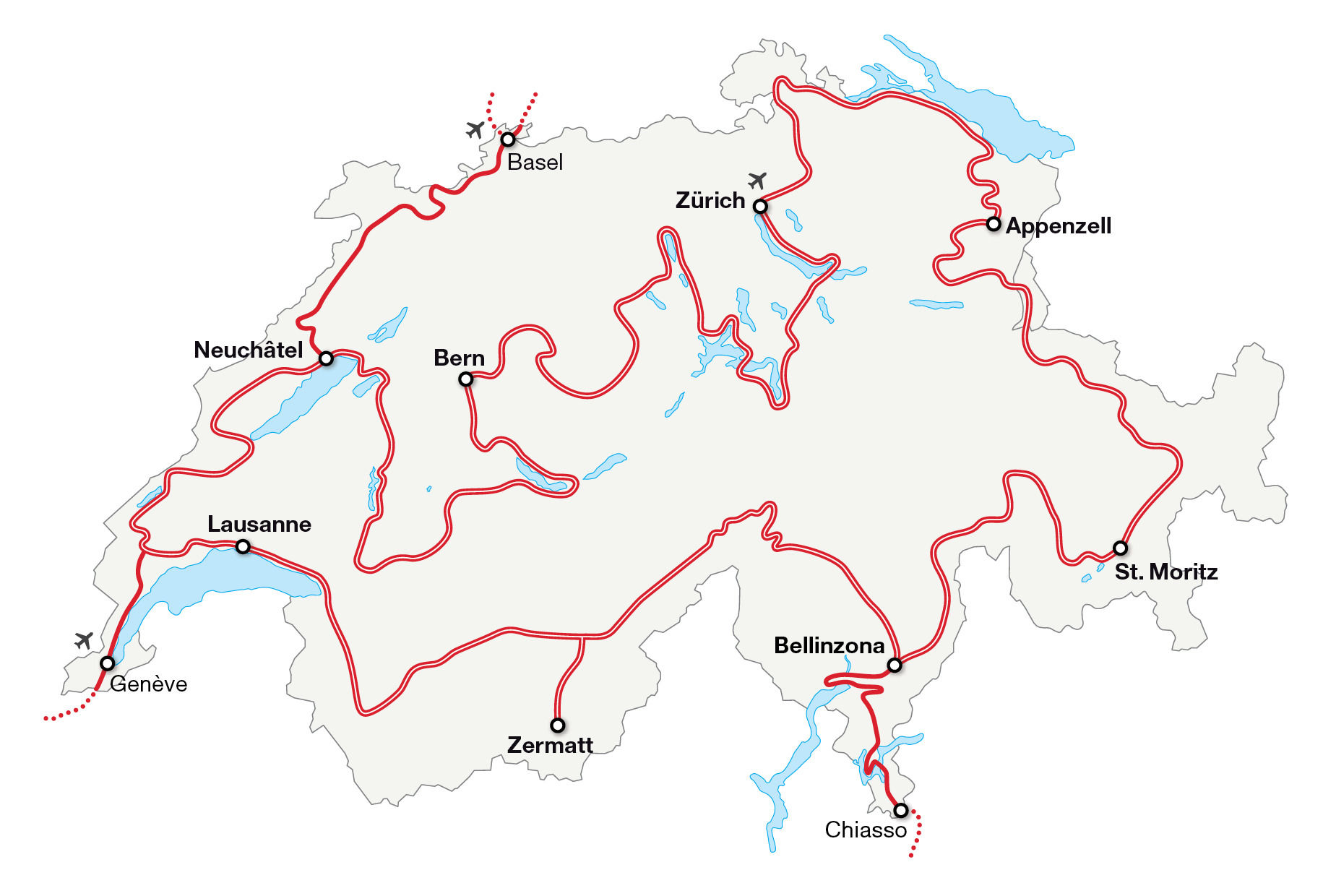
Stage 1: Zurich – Appenzell
The most diverse stage of all – starting in the trendy city of Zurich, you’ll continue on to Zurich’s wine country, the thundering Rhine Falls and on to the historic book and textile city of St. Gallen before ending up in rural Appenzell.
了解更多Stage 2: Appenzell – St. Moritz
The stage with the most records – from Europe’s smallest town, Werdenberg, to Switzerland’s oldest city, Chur, and on to the Salginatobel Bridge, Switzerland’s only world monument, before you end up in St. Moritz.
了解更多Stage 3: St. Moritz – Bellinzona
Stage with the biggest change in altitude – from Alpine St. Moritz, at 1,822 metres above sea level, the route descends down into the imposing Bellinzona, at around 240 metres above sea level.
了解更多Stage 4: Bellinzona – Zermatt
The stage with the most bends – the Tremola snakes its way from Airolo up to the Gotthard Pass. At its most spectacular point, over a length of four kilometres the road climbs a height of 300 metres in 24 hairpin bends, each with its own name.
了解更多Stage 5: Zermatt – Lausanne
This is the stage where it’s time to get out – Zermatt is not only known for the Matterhorn, but also for being a car-free village. Visitors must leave their car in Täsch and take the train to Zermatt and back to Täsch, where the journey continues on by car through Valais to Lake Geneva.
了解更多Stage 6: Lausanne – Neuchâtel
The stage with the watchmaking tradition – watchmaking and innovation used to play out mainly in Geneva. Watchmaking soon spread across the Jura mountain range to other regions, including Le Sentier and Neuchâtel.
了解更多Stage 7: Neuchâtel – Bern
The stage with the most water – from Lake Neuchâtel, the route takes you to Lake Murten, Lake Schiffenen, Lake Gruyère, Lake Thun, Lake Brienz and finally along the Aare River to the capital, Bern.
了解更多Stage 8: Bern – Zurich
The stage with the most Swiss history – from Bern, the route leads into the Canton of Uri, the location of the well-known Rütli meadow, where the oath marking the alliance of the three original cantons was sworn in 1291.
了解更多Access road: Basel – Neuchâtel
There are around 40 museums in the cultural metropolis of Basel. From here, the access road coasts along the Doubs River to the towns of La Chaux-de-Fonds and Le Locle, both known for their watchmaking traditions. The route ends in Neuchâtel.
了解更多Access road: Chiasso – Bellinzona
From Chiasso, the route meanders into the palm tree-lined streets of Lugano, a starting point for excursions to several local mountains. It continues to the historic old town of Locarno and then on to Bellinzona with its castles, which are a UNESCO World Heritage site.
了解更多Access road: Geneva – Saint-George
From the cosmopolitan Swiss city of Geneva, where the Jet d’Eau, a 140-metre-high fountain in Lake Geneva, shoots into the sky, the route continues on to Nyon before ending up in Saint-George, which makes up part of the Vaud Jura Park.
了解更多路段1:苏黎世-阿彭策尔
这是全程中最多姿多彩的路段——从时尚都市苏黎世出发,前往苏黎世的葡萄酒之乡、水声隆隆的莱茵瀑布,然后前往历史悠久的图书和纺织之城圣加仑,最后在阿彭策尔的乡村结束该段行程。
- 175 km 距离
- 1780 m 上升
- 1446 m 下降
路段2:阿彭策尔-圣莫里茨
纪录最多的路段——从欧洲最小的城镇韦尔登堡到瑞士最古老的城市库尔,再到瑞士唯一的世界遗迹萨尔吉纳峡谷桥,最后到达圣莫里茨。
- 200 km 距离
- 4541 m 上升
- 3561 m 下降
路段3:圣莫里茨-卢加诺
海拔变化最大的路段:从海拔1822米的阿尔卑斯山圣莫里茨向下到达海拔270米的卢加诺棕榈树林荫大道。
- 157 km 夏季距离
- 4285 m 夏季上升
- 5721 m 夏季下降
- 150 km 冬季距离
- 4332 m 冬季上升
- 5767 m 冬季下降
支线:基亚索-贝林佐纳
从基亚索出发,一路蜿蜒进入卢加诺棕榈树成行的街道,这里是游览当地几座山峰的起点。前往历史悠久的洛迦诺老城,然后去往贝林佐纳,那里的城堡已被联合国教科文组织列为世界文化遗产。
- 105 km 距离
- 1686 m 上升
- 1666 m 下降
路段4:卢加诺-采尔马特
弯道最多的路段——特莱莫拉一路蜿蜒,从艾罗洛通往圣哥达山口。其中最壮观的路段长达4公里,沿24个发夹弯攀升300米,每个发夹弯都有自己的名字。
- 195 km 夏季距离
- 5816 m 夏季上升
- 4713 m 夏季下降
- 185 km 冬季距离
- 6741 m 冬季上升
- 5639 m 冬季下降
路段5:采尔马特-洛桑
该路段需要改变交通方式——采尔马特不仅因马特宏峰而举世闻名,还因这是一座禁止汽车通行的村庄。游客须把车停放在塔什,然后搭乘火车前往采尔马特,游览结束后再返回塔什,继续驾车穿过瓦莱州前往日内瓦湖。
- 178 km 距离
- 1688 m 上升
- 2750 m 下降
支线:日内瓦-圣乔治
从瑞士的国际大都市日内瓦(日内瓦湖大喷泉的水柱高达140米)出发,前往尼永,最后到达圣乔治,这里是沃州汝拉公园的一部分。
- 55 km 距离
- 734 m 上升
- 257 m 下降
路段6:洛桑-纳沙泰尔
制表传统路段——最初,制表和创新主要集中在日内瓦,后来,制表业很快就翻越了汝拉山脉,扩展至其他地区,包括勒桑捷和纳沙泰尔。
- 171 km 距离
- 2734 m 上升
- 2675 m 下降
支线:巴塞尔-纳沙泰尔
文化都市巴塞尔拥有大约40家博物馆。从这里出发,支线沿杜河通往以制表传统闻名的拉绍德封和力洛克,终点是纳沙泰尔。
- 160 km 距离
- 2978 m 上升
- 2800 m 下降
路段7:纳沙泰尔-伯尔尼
水景最多的路段——以纳沙泰尔湖为起点,沿途经过穆尔滕湖、希费嫩湖、格吕耶尔湖、图恩湖、布里恩茨湖,最后沿阿勒河到达首都伯尔尼。
- 252 km 距离
- 2860 m 上升
- 2760 m 下降
路段8:伯尔尼-琉森-苏黎世
瑞士历史气息最浓郁的路段——从伯尔尼出发,进入乌里州,著名的吕特利草地位于该州,1291年,瑞士最早的三个州正是在这里宣誓结盟。
- 315 km 距离:伯尔尼 – 苏黎世
- 5209 m 总爬升高度:伯尔尼 – 苏黎世
- 5287 m 总下降高度:伯尔尼 - 苏黎世