Grand Tour Stage Facts
Intro
A road trip on the Grand Tour of Switzerland requires effective preparation. To allow you to do this, Switzerland Tourism (ST) has compiled facts on the distance of each stage, as well as the total ascent and descent. This way, nothing will stand in your way for an unforgettable road trip through Switzerland.
Find the GPX-Tracks of the whole Grand Tour below
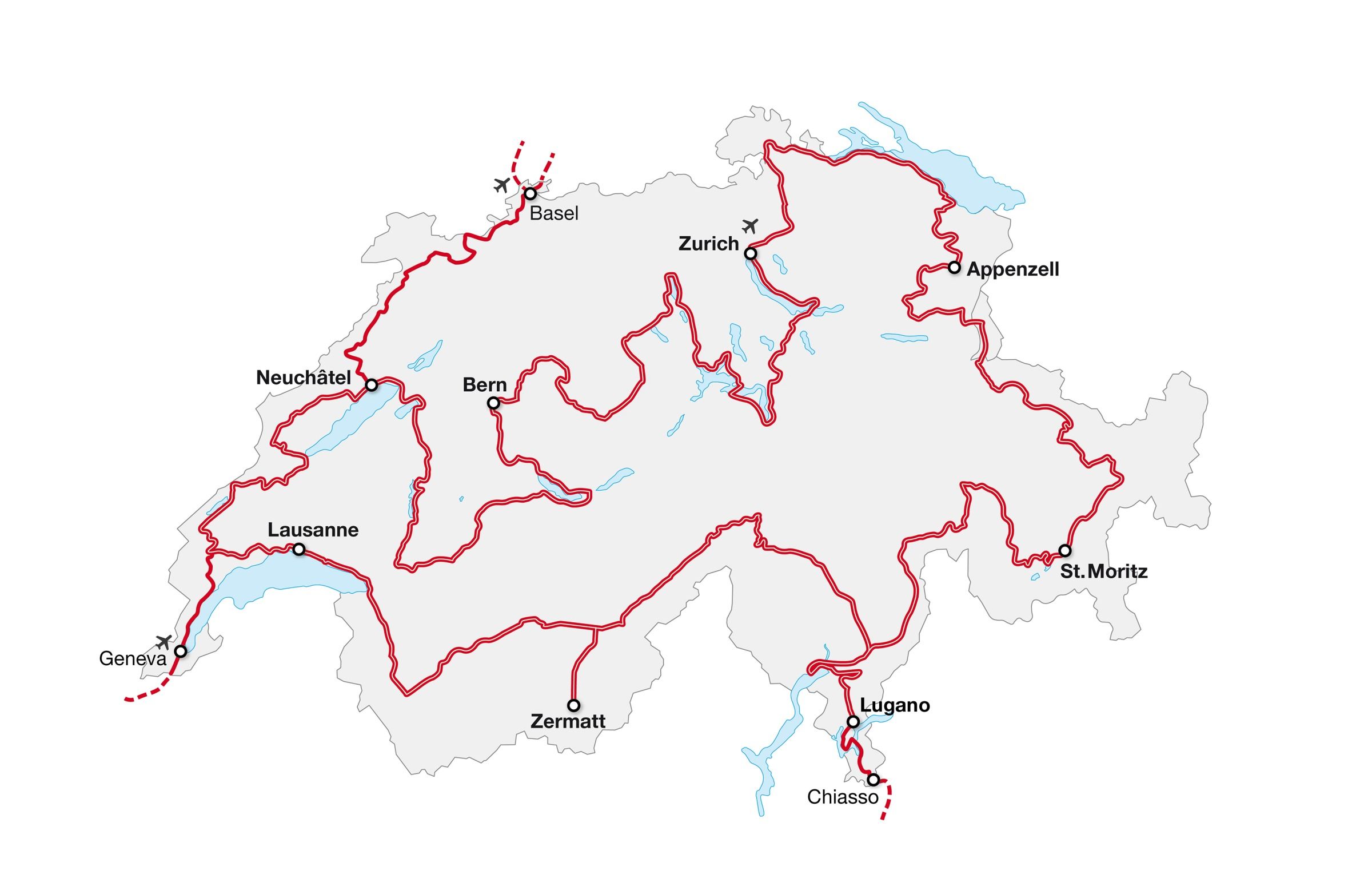
구간 1: 취리히 – 아펜첼
가장 다채로운 구간 – 트렌디한 도시 취리히(Zurich)에서 시작해 취리히 지역의 와인 생산지와 우렁찬 라인 폭포를 지나 고서와 직물의 도시 생갈렌(St. Gallen)을 거쳐 시골풍의 아펜첼(Appenzell)에서 여정을 마무리한다.
자세히구간 2: 아펜첼 – 생모리츠
세계 기록을 제일 많이 보유한 구간 – 유럽에서 제일 작은 마을 베르덴베르크(Werdenberg), 스위스에서 제일 오래된 도시 쿠어(Chur), 스위스 유일의 세계 기념비 잘기나토벨(Salginatobel) 다리를 지나 생모리츠(St. Moritz)에서 여정을 마무리한다.
자세히구간 3: 생모리츠 – 루가노
고도 변화가 가장 큰 구간 – 알프스 마을 생모리츠(St. Moritz)가 있는 해발고도 1,822m에서 가로수가 야자나무인 루가노(Lugano)가 있는 해발고도 270m까지.
자세히구간 4: 루가노 – 체르마트
급커브가 제일 많은 구간 – 트레몰라(Tremola) 고갯길이 아이롤로(Airolo)에서 시작해 고타드 고개(Gotthard Pass)를 오른다. 길이가 4,000km가 넘는 도로는 24개의 급커브를 지나며 고도 300m를 오르는데, 급커브 하나하나마다 이름이 있다.
자세히구간 5: 체르마트 – 로잔
밖으로 나가야 할 구간 – 체르마트(Zermatt)는 마테호른(Matterhorn) 뿐만 아니라 휘발유 차량 금지 마을로도 잘 알려져 있다. 태쉬(Täsch)에 주차하고, 기찰로 체르마트까지 왕복 이동해야 한다. 그 뒤로는 발레(Valais) 지역을 통과해 레만(Léman) 호 지역으로 이동한다.
자세히구간 6: 로잔 – 뉴샤텔
시계 제조 전통이 깃든 구간 – 시계 제조와 혁신은 주로 제네바에서 활발했다. 시계 제조는 곧 유라 산맥을 따라 다른 지역으로 퍼져 나갔는데, 르 상티에(Le Sentier)와 뉴샤텔(Neuchâtel)도 거기에 포함된다.
자세히구간 7: 뉴샤텔 – 베른
물이 제일 많은 구간 – 뉴샤텔(Neuchâtel) 호수에서 시작해 무어텐(Murten) 호수, 쉬페넨(Schiffenen) 호수, 그뤼에르(Gruyère) 호수, 툰(Thun) 호수, 브리엔츠(Brienz) 호수를 따라 여정이 이어지다가 마침내 스위스의 수도 베른(Bern)을 흐르는 아레(Aare) 강을 따라간다.
자세히구간 8: 베른 – 취리히
스위스 역사가 가장 깊게 베인 구간 – 베른(Bern)에서 시작한 루트는 우리(Uri) 칸톤으로 이어지는데, 잘 알려진 뤼틀리(Rütli) 들판이 있는 곳이다. 1291년, 3 개의 칸톤이 모여 스위스 연방을 결성한 곳이다.
자세히접근 가능한 도로: 바젤 – 뉴샤텔
문화의 도시 바젤(Basel)에는 약 40개의 박물관이 있다. 여기에서 접근 가능한 도로가 두(Doubs) 강을 따라 라쇼드퐁(Chaux-de-Fonds) 및 르 로클(Le Locle) 마을까지 이어진다. 모두 시계 제조 전통으로 잘 알려진 마을이다. 루트는 뉴샤텔(Neuchâtel)에서 끝난다.
자세히접근 가능한 도로: 키아쏘 – 벨린초나
키아쏘(Chiasso)에서 야자수가 늘어선 루가노까지 루트가 구불구불 이어진다. 루가노는 이 지역에 있는 여러 산으로 향하는 여정의 좋은 출발지가 되어준다. 유서 깊은 구시가지가 있는 로카르노(Locarno)를 지나 유네스코 세계유산으로 등록된 고성이 있는 벨린초나(Bellinzona)까지 여정이 이어진다.
자세히접근 가능한 도로: 제네바 – 생조쥬
스위스의 대도시 제네바(Geneva)는 레만 호 140m 위로 솟아오르는 분수, 젯또(Jet d’Eau)가 있는 곳이다. 니옹(Nyon) 마을을 지나 보 유라 공원(Vaud Jura Park)의 일부를 이루는 생조쥬(Saint-George)에서 여정이 마무리된다.
자세히Stage 1: Zurich - Appenzell
The most diverse stage of all – starting in the trendy city of Zurich, you’ll continue on to Zurich’s wine country, the thundering Rhine Falls and on to the historic book and textile city of St. Gallen before ending up in rural Appenzell.
- 173 km Distance
- 1780 m Total ascent
- 1446 m Total descent
Stage 2: Appenzell - St. Moritz
The stage with the most records – from Europe’s smallest town, Werdenberg, to Switzerland’s oldest city, Chur, and on to the Salginatobel Bridge, Switzerland’s only world monument, before you end up in St. Moritz.
- 199 km Distance
- 4541 m Total ascent
- 3561 m Total descent
Stage 3: St. Moritz – Lugano
The stage with the biggest change in altitude – from Alpine St. Moritz, at 1,822 metres above sea level, down to the palm tree-lined streets of Lugano, at 270 metres above sea level.
- 223 km Distance summer
- 4285 m Total ascent summer
- 5721 m Total descent summer
- 216 km Distance winter
- 4332 m Total ascent winter
- 5767 m Total descent winter
Access road: Chiasso - Bellinzona
From Chiasso, the route meanders into the palm tree-lined streets of Lugano, a starting point for excursions to several local mountains. It continues to the historic old town of Locarno and then on to Bellinzona with its castles, which are a UNESCO World Heritage Site.
- 107 km Distance
- 1686 m Total ascent
- 1666 m Total descent
Stage 4: Lugano - Zermatt
The stage with the most bends – the Tremola snakes its way from Airolo up to the Gotthard Pass. At its most spectacular point, over a length of four kilometres the road climbs a height of 300 metres in 24 hairpin bends, each with its own name.
- 260 km Distance summer
- 5816 m Total ascent summer
- 4713 m Total descent summer
- 250 km Distance winter
- 6741 m Total ascent winter
- 5639 m Total descent winter
Stage 5: Zermatt - Lausanne
This is the stage where it’s time to change mode of transport – Zermatt is not only known for the Matterhorn, but also for being a car-free village. Visitors must leave their car in Täsch and take the train to Zermatt and back to Täsch, where the journey continues on by car through Valais to Lake Geneva.
- 177 km Distance
- 1688 m Total ascent
- 2750 m Total descent
Access Road: Geneva - Saint George
From the cosmopolitan Swiss city of Geneva, where the Jet d’Eau fountain shoots 140 metres into the sky out of Lake Geneva, the route continues on to Nyon before ending up in Saint-George, which makes up part of the Vaud Jura Park.
- 53 km Distance
- 734 m Total ascent
- 257 m Total descent
Stage 6: Lausanne - Neuchâtel
The stage of the watchmaking tradition – in the beginning, watchmaking and innovation used to play out mainly in Geneva. Watchmaking soon spread across the Jura mountain range to other regions, including Le Sentier and Neuchâtel.
- 173 km Distance
- 2734 m Total ascent
- 2675 m Total descent
Access road: Basel - Neuchâtel
There are around 40 museums in the cultural metropolis of Basel. From here, the access road coasts along the Doubs River to the towns of La Chaux-de-Fonds and Le Locle, both known for their watchmaking traditions. The route ends in Neuchâtel.
- 155 km Distance
- 2978 m Total ascent
- 2800 m Total descent
Stage 7: Neuchâtel - Bern
The stage with the most water – from Lake Neuchâtel, the route takes you to Lake Murten, Lake Schiffenen, Lake Gruyère, Lake Thun, Lake Brienz and finally along the Aare River to the capital, Bern.
- 250 km Distance
- 2860 m Total ascent
- 2760 m Total descent
Stage 8: Bern - Lucerne - Zurich
The stage with the most Swiss history – from Bern, the route leads into the Canton of Uri, the location of the well-known Rütli meadow, where the oath marking the alliance of the three original cantons was sworn in 1291.
- 180 km Distance Bern - Lucerne
- 1428 m Total ascent Bern - Lucerne
- 1527 m Total descent Bern - Lucerne
- 139 km Distance Lucerne - Zurich
- 3781 m Total ascent Lucerne - Zurich
- 3760 m Total descent Lucerne - Zurich