
Grand Tour Stage Facts
Scroll
Intro
A road trip on the Grand Tour of Switzerland requires effective preparation. To allow you to do this, Switzerland Tourism (ST) has compiled facts on the distance of each stage, as well as the total ascent and descent. This way, nothing will stand in your way for an unforgettable road trip through Switzerland.
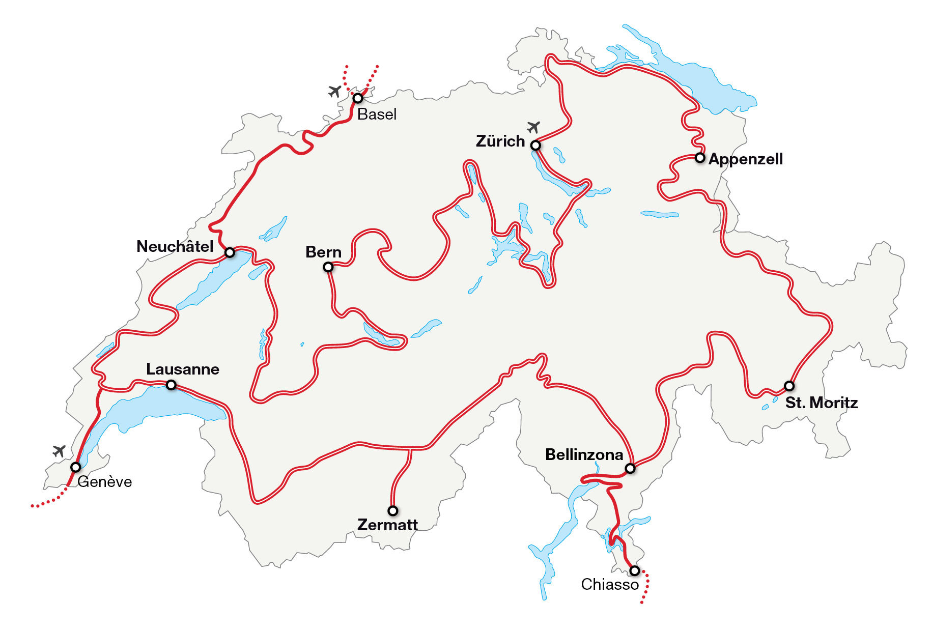
Stage 1: Zurich – Appenzell
The most diverse stage of all – starting in the trendy city of Zurich, you’ll continue on to Zurich’s wine country, the thundering Rhine Falls and on to the historic book and textile city of St. Gallen before ending up in rural Appenzell.
詳細をみるStage 2: Appenzell – St. Moritz
The stage with the most records – from Europe’s smallest town, Werdenberg, to Switzerland’s oldest city, Chur, and on to the Salginatobel Bridge, Switzerland’s only world monument, before you end up in St. Moritz.
詳細をみるStage 3: St. Moritz – Bellinzona
Stage with the biggest change in altitude – from Alpine St. Moritz, at 1,822 metres above sea level, the route descends down into the imposing Bellinzona, at around 240 metres above sea level.
詳細をみるStage 4: Bellinzona – Zermatt
The stage with the most bends – the Tremola snakes its way from Airolo up to the Gotthard Pass. At its most spectacular point, over a length of four kilometres the road climbs a height of 300 metres in 24 hairpin bends, each with its own name.
詳細をみるStage 5: Zermatt – Lausanne
This is the stage where it’s time to get out – Zermatt is not only known for the Matterhorn, but also for being a car-free village. Visitors must leave their car in Täsch and take the train to Zermatt and back to Täsch, where the journey continues on by car through Valais to Lake Geneva.
詳細をみるStage 6: Lausanne – Neuchâtel
The stage with the watchmaking tradition – watchmaking and innovation used to play out mainly in Geneva. Watchmaking soon spread across the Jura mountain range to other regions, including Le Sentier and Neuchâtel.
詳細をみるStage 7: Neuchâtel – Bern
The stage with the most water – from Lake Neuchâtel, the route takes you to Lake Murten, Lake Schiffenen, Lake Gruyère, Lake Thun, Lake Brienz and finally along the Aare River to the capital, Bern.
詳細をみるStage 8: Bern – Zurich
The stage with the most Swiss history – from Bern, the route leads into the Canton of Uri, the location of the well-known Rütli meadow, where the oath marking the alliance of the three original cantons was sworn in 1291.
詳細をみるAccess road: Basel – Neuchâtel
There are around 40 museums in the cultural metropolis of Basel. From here, the access road coasts along the Doubs River to the towns of La Chaux-de-Fonds and Le Locle, both known for their watchmaking traditions. The route ends in Neuchâtel.
詳細をみるAccess road: Chiasso – Bellinzona
From Chiasso, the route meanders into the palm tree-lined streets of Lugano, a starting point for excursions to several local mountains. It continues to the historic old town of Locarno and then on to Bellinzona with its castles, which are a UNESCO World Heritage site.
詳細をみるAccess road: Geneva – Saint-George
From the cosmopolitan Swiss city of Geneva, where the Jet d’Eau, a 140-metre-high fountain in Lake Geneva, shoots into the sky, the route continues on to Nyon before ending up in Saint-George, which makes up part of the Vaud Jura Park.
詳細をみるStage 1: Zurich - Appenzell
The most diverse stage of all – starting in the trendy city of Zurich, you’ll continue on to Zurich’s wine country, the thundering Rhine Falls and on to the historic book and textile city of St. Gallen before ending up in rural Appenzell.
- 175 km Distance
- 1780 m Total ascent
- 1446 m Total descent
Stage 2: Appenzell - St. Moritz
The stage with the most records – from Europe’s smallest town, Werdenberg, to Switzerland’s oldest city, Chur, and on to the Salginatobel Bridge, Switzerland’s only world monument, before you end up in St. Moritz.
- 200 km Distance
- 4541 m Total ascent
- 3561 m Total descent
Stage 3: St. Moritz – Lugano
The stage with the biggest change in altitude – from Alpine St. Moritz, at 1,822 metres above sea level, down to the palm tree-lined streets of Lugano, at 270 metres above sea level.
- 157 km Distance summer
- 4285 m Total ascent summer
- 5721 m Total descent summer
- 150 km Distance winter
- 4332 m Total ascent winter
- 5767 m Total descent winter
Access road: Chiasso - Bellinzona
From Chiasso, the route meanders into the palm tree-lined streets of Lugano, a starting point for excursions to several local mountains. It continues to the historic old town of Locarno and then on to Bellinzona with its castles, which are a UNESCO World Heritage Site.
- 105 km Distance
- 1686 m Total ascent
- 1666 m Total descent
Stage 4: Lugano - Zermatt
The stage with the most bends – the Tremola snakes its way from Airolo up to the Gotthard Pass. At its most spectacular point, over a length of four kilometres the road climbs a height of 300 metres in 24 hairpin bends, each with its own name.
- 195 km Distance summer
- 5816 m Total ascent summer
- 4713 m Total descent summer
- 185 km Distance winter
- 6741 m Total ascent winter
- 5639 m Total descent winter
Stage 5: Zermatt - Lausanne
This is the stage where it’s time to change mode of transport – Zermatt is not only known for the Matterhorn, but also for being a car-free village. Visitors must leave their car in Täsch and take the train to Zermatt and back to Täsch, where the journey continues on by car through Valais to Lake Geneva.
- 178 km Distance
- 1688 m Total ascent
- 2750 m Total descent
Access Road: Geneva - Saint George
From the cosmopolitan Swiss city of Geneva, where the Jet d’Eau fountain shoots 140 metres into the sky out of Lake Geneva, the route continues on to Nyon before ending up in Saint-George, which makes up part of the Vaud Jura Park.
- 55 km Distance
- 734 m Total ascent
- 257 m Total descent
Stage 6: Lausanne - Neuchâtel
The stage of the watchmaking tradition – in the beginning, watchmaking and innovation used to play out mainly in Geneva. Watchmaking soon spread across the Jura mountain range to other regions, including Le Sentier and Neuchâtel.
- 171 km Distance
- 2734 m Total ascent
- 2675 m Total descent
Access road: Basel - Neuchâtel
There are around 40 museums in the cultural metropolis of Basel. From here, the access road coasts along the Doubs River to the towns of La Chaux-de-Fonds and Le Locle, both known for their watchmaking traditions. The route ends in Neuchâtel.
- 160 km Distance
- 2978 m Total ascent
- 2800 m Total descent
Stage 7: Neuchâtel - Bern
The stage with the most water – from Lake Neuchâtel, the route takes you to Lake Murten, Lake Schiffenen, Lake Gruyère, Lake Thun, Lake Brienz and finally along the Aare River to the capital, Bern.
- 252 km Distance
- 2860 m Total ascent
- 2760 m Total descent
Stage 8: Bern - Lucerne - Zurich
The stage with the most Swiss history – from Bern, the route leads into the Canton of Uri, the location of the well-known Rütli meadow, where the oath marking the alliance of the three original cantons was sworn in 1291.
- 315 km Distance Bern - Zürich
- 5209 m Total ascent Bern - Zürich
- 5287 m Total descent Bern - Zürich